| The Lustik Travel Home Page |
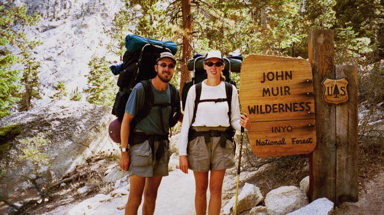
September 17 - 30, 2002
Please find the map and profile of the John Muir Trail by clicking here.
Tuesday, September 17, 2002 Day 11,
JMT: 11.6 miles 119.0
total miles
It was 39° at 7:00 AM and we were under way by 8:00. We stopped briefly at the Muir Trail Ranch to check out the facility. We learned that this is the final week of their season, and they permit “short stays” of a night or two during this week. They only book weeklong stays during the rest of the season. We calculated that we would have spent a little more money here, but we may have enjoyed our stay more.
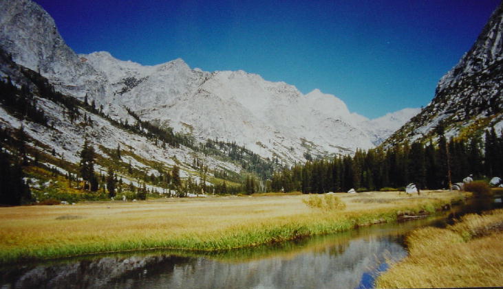
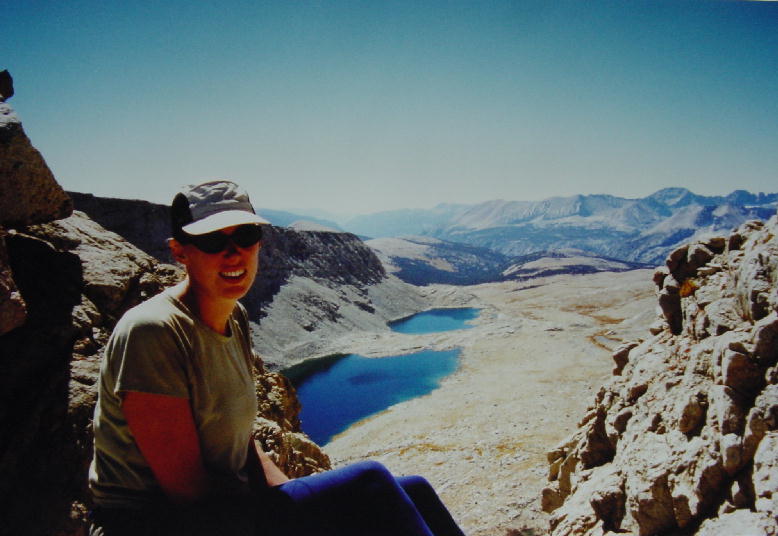
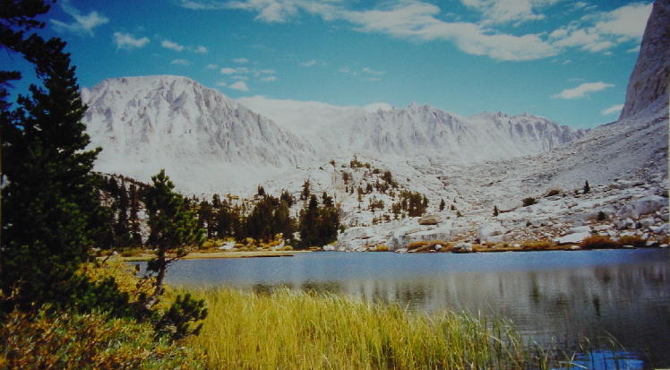
It was 9:30 by the time we got back on the JMT, which put us at our halfway point (109.1 miles). We began an all day climb up the San Joaquin River Canyon that took us into Kings Canyon National Park. We continued a short steep switchback climb up to hanging Evolution Valley, a gem of this park. Christine was in good spirits today. We forded Evolution Creek, our first crossing that we couldn’t rock-hop. We took our boots and socks off so that we could wade across the stream. The rocky bottom was torture on our tender feet, but it was brief. We later learned that we could have used a log to cross the creek up around the bend. Our guidebook mentions many dangerous stream fords, but we haven’t faced any of them this late I the season. The early season snowmelt makes raging rivers out of the creeks that we hopped across. The stream crossings have been no challenge this time of year.
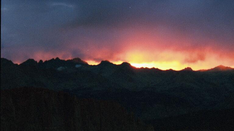
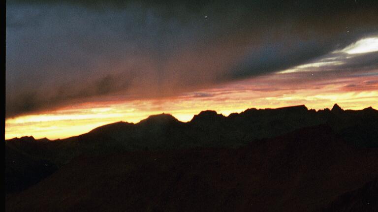
We stopped at McClure Meadow for dinner at 4:00 and met a threesome out hiking on the JMT: Jim, Caroline and Troy. We continued walking after dinner up to Colby Meadow (9700’) where our campsite had us perched above the meadow looking west. Clouds had blown in this afternoon and we were treated to an amazing sunset. We sat in the warmth of our tent and watched the display through the open rainfly. It had been a good day.
Day 11 – Christine
Well today was an okay day. The days are just long and steady. Joe's been taking a few more breaks and that helps me. I don't mind if he goes ahead of me, but I feel like I am chasing him when I have to go to the bathroom or really need a break. If I just take a break I fall even further behind. At this point I am just amazed I wanted to do this and that I thought I could do this. And I am doing it, but I don’t think I'll want to do a long distance hike where we are so set into a schedule again. Once the body accepted that this was happening it has been pretty good. It takes me up and over the mountains with minimal complaining. Physically it is already clear to me I can do this; it is just my mind that gets bored.
One of the things I really enjoy are the Juniper trees. They are so pretty and we both love finding a pretty grove of Junipers. I've learned about a new bird. A common bird up here in the High Sierras is the Clark's Nutcracker. It is a white and black bird and it flies between the trees making loud Kaaaaas. The Clark's Nutcracker stays in the High Sierras year around and doesn't leave in winter. In lower elevations it is very common for us to see Stellar Jays. They are pretty blue jays but they are also noisy birds.
One more thing I've been meaning to write about is the sound of the planes. We never cross roads so we don't hear things like cars at all. The only sound we hear outside of nature are planes. This high elevation really makes a difference and we hear the planes as if they were landing above us. Sometimes above 11,000 feet I would swear I should be able to tell which airline it is. We can usually see them pretty clearly as the skies are always so clear.
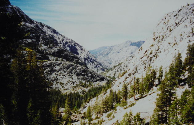
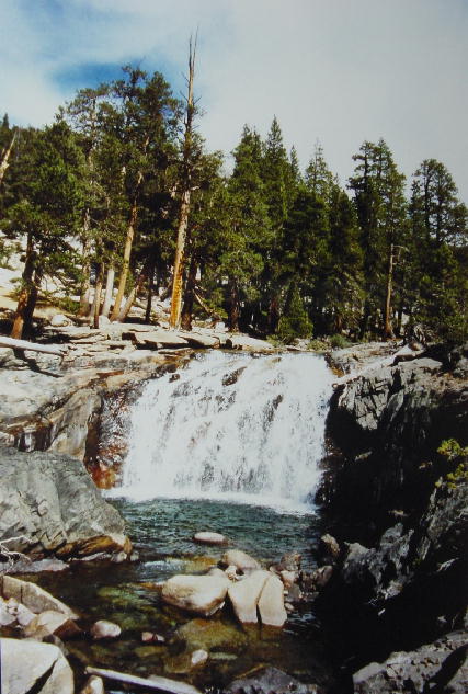
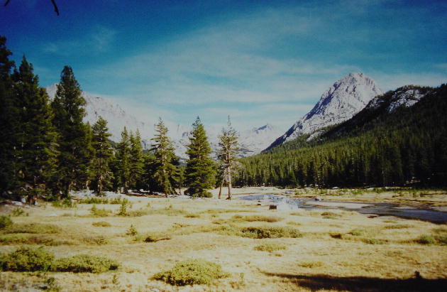
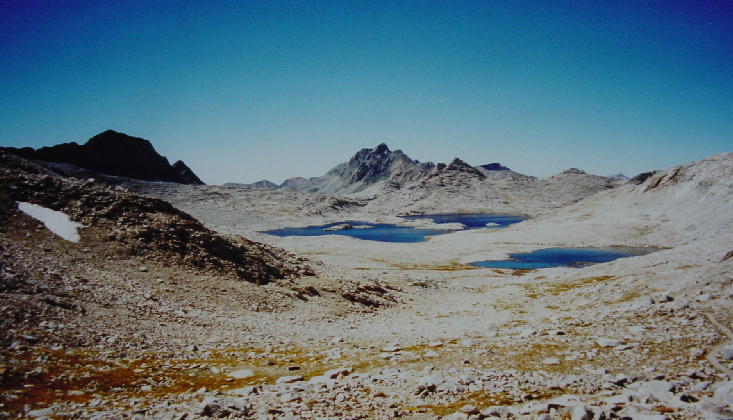
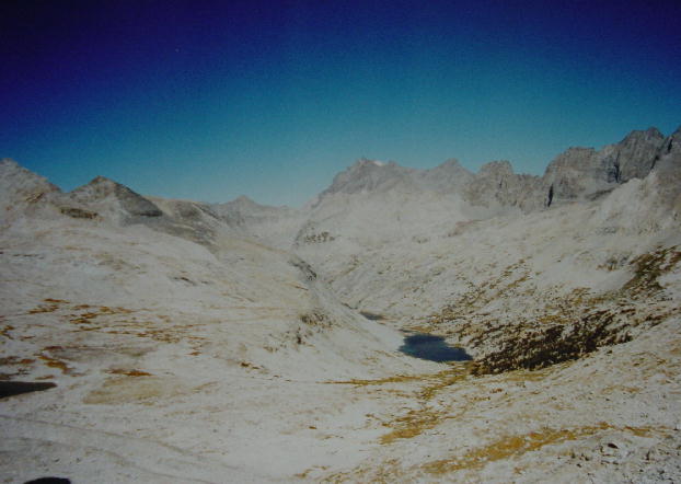
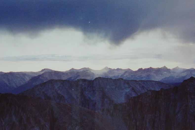
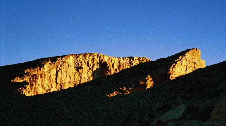
1) Looking Northeast above San Joaquin canyon. 2) Evolution Creek Cascades. 3) Looking East across McClure meadow up Evolution Valley.
Wednesday, September 18, 2002 Day 12,
JMT: 13.4 miles 132.4 total miles
It was 29° at 7:00 AM, a cold clear morning. We began a tough climb up to Evolution Lake at 8:00 that served well to warm us. It was already turning into a hot day by the time we reached the lake. We make frequent stops on chilly mornings like this as we strip off our extra layers of clothing. We hike with long-johns under our shorts, a fleece pullover, hat and gloves, until it is warm enough that we are back to our standard shorts and T-shirts.
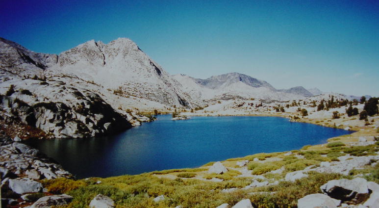
Evolution Valley and this entire area are named after the major thinkers on evolution. The high lakes in this area are spectacular, though treeless. We again met up with the threesome from yesterday taking a break along Wanda Lake. Christine and I got a laugh out of the ironic description of this lake in our guidebook: “…and finally arrive at huge, wonderfully barren Wanda Lake, named after one of John Muir’s daughters…”
We became more acquainted with the threesome as we walked with them on and off today. Jim completed a hike of the Appalachian Trail (AT) from 1980-83, did the Continental Divide Trail (the CDT is a 2700-mile incomplete patchwork of trails from the NM/Mexico border to the MT/Canada border along the continental divide) in 1985, and is now section hiking the Pacific Crest Trail (PCT). That’s a pretty impressive hiking resume. This is Caroline’s first long hike, but Troy did 700 miles of the AT in 1995. They were all out here from western Mass. doing the JMT. We enjoyed their company.
We reached beautiful Muir Pass (11,955’) at 2:00 and found one of the Brit Groups that we last saw on the morning of the helicopter evacuation. We learned that the entire group has been jumping on and off the trail due to poor food management. They lost another hiker due to a foot/knee injury, so their road crew had grown to five and the hiking teams were now two groups with six in each. We were pleased to hear that the guy that had the seizure was released from the hospital that same day. He was diagnosed with Acute Mountain Sickness (AMS), which enjoys rapid recovery as soon as the victim returns to lower elevation. The schedule for the Brits has them summiting Whitney the day before we plan to, so we shouldn’t see them again. They are hiking out at Bishop Pass tomorrow for food and then coming back in at Kearsarge Pass. They are missing several sections of the JMT through their itinerary, but they’re still probably hiking the same number of miles as we are.
There is a substantial stone hut erected on Muir Pass in honor of John Muir. It is intended for use as a storm shelter due to the frequent quick storms that can surprise hikers in this region. We however, were enjoying a splendid clear day as we crossed the pass. We began a cool windy descent down the east side of the pass after a long break on the top. The rocky trail was brutal so we stopped at Helen Lake (named for another of Muir’s daughters) to soak our battered feet. Christine even soaked her sore knees in the cold water.
We trudged on down into LeConte Canyon for what seemed like a great distance, but really wasn’t. We stopped to speak with a National Park Service biologist that was busy removing fish from the high mountain lakes. We learned that none of the trout are native in the lakes above 10,000’, and they are predating on the native yellow-legged frog. The stocking of the trout in these lakes dates back to the 1850’s, but the biologists have a special electric fish catching device that they hope will eradicate the threat to the frogs.
We quit walking at 6:00 just before reaching Big Pete Meadow (8710’). It had been another long day, but we were doing well. We’ve been watching the moon recently, and it appears to be nearly full tonight.
Day 12 – Christine
As I've said before morning is still my least favorite time. I'm woken by the sound of the zipper as Joe goes outside to get the granola and milk and my first instinct is to snuggle deeper. Even though the nights aren't as cold as we had initially feared, the mornings are still plenty cold to jump out into from the sleeping bag. My hands just become ice if I try to do anything like brush my teeth and I feel guilty but I don’t even offer to do the morning dishes. Also, the first hour of walking is the worst as my body wakes up and warms up. My feet seem to chant, "No more walking…No more boots" and my knees accentuate the chants with Ow, Ow, Ow. Every once in awhile the hips and shoulders join in but for the most part the shoulders hurt more toward the end of the day when they are tired. Ah well, seven more mornings.
Over all today was a good day. The last couple of days we've been passing some of the same people and today we saw the Brits! I was really glad to see them. They are sure doing it the hard way but with all their skipping of parts they must be hiking at least as much as we are because you have to hike so far to get on and off the trail. But I was glad to know most of them will climb Whitney and that the man who had the seizure is well. I admit the social aspect of the trail helps me to enjoy the days, and it gives my mind something to look forward to other than the next break.
The water is so amazingly clear and beautiful up here. I figure God does his best to send good water down from the mountains unfortunately it doesn't get far before people mess it up. We filter all our water but we pass a lot of people who use chlorine pills. I would be tempted to just drink more plain water out of the beautiful clear streams instead of always tasting the chlorine. As it is, I love the taste of this water!
My toes are getting pretty messed up. They have weird blisters on them in between the toes, but the blisters don't rub or hurt and they never pop so I don't even tape them. Also my left big toe is really swollen. At first I could feel it and it felt like there was something in my boot and then it itched like crazy for a couple days but now it is just swollen and it doesn't bother me so I'm not going to worry about it. I wish I could stop kicking the rocks though. The more I try to concentrate on getting my feet up and over every rock the more I kick! It's just that so often that is all the path is made up of--big and little rocks. It is tiring walking on them. Coming down off Muir Pass was harsh today. The trail was really hard, very rocky with large rocks and steps. So often I wander how short people make it on this trail. There are times when the stone steps that go up and down the mountains are higher than my knees. And when we have to walk down for miles on steps and rocks like this my toes just hit the front of my boots over and over again.
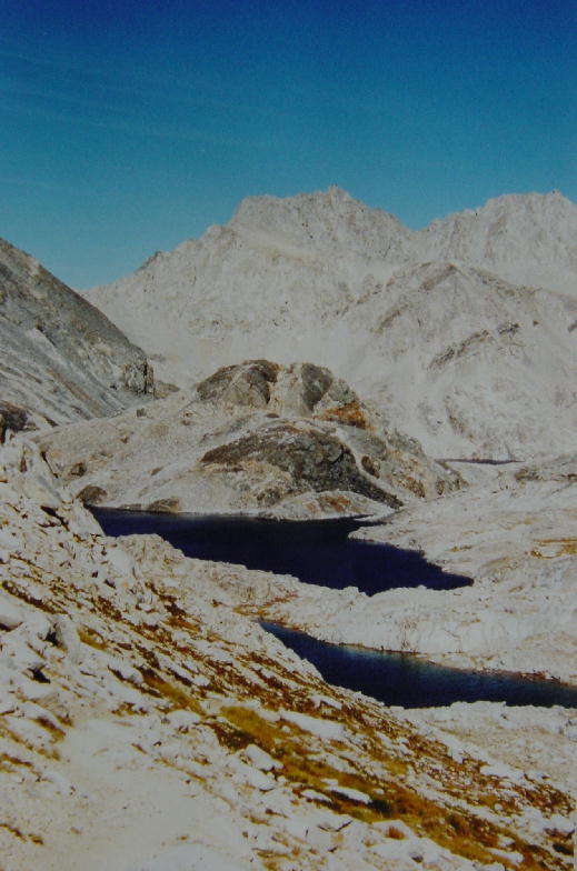
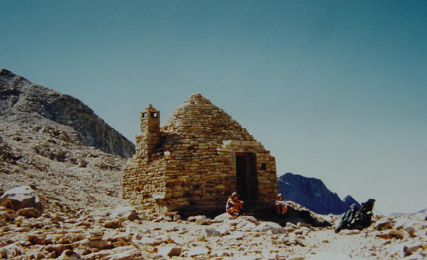
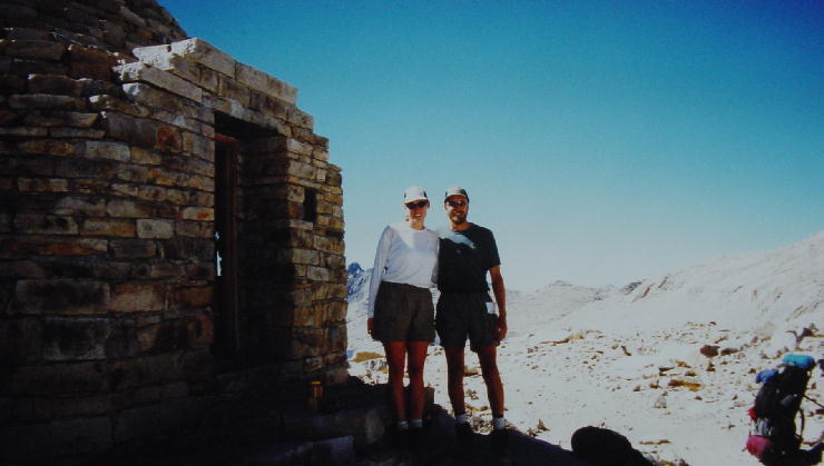
1) Evolution Lake. 2) Wanda Lake from Muir Pass. 3) Looking east from Muir Pass down on Helen Lake. 4) The Muir Hut, with Caroline and Christine chatting. 5) Christine and Joe in front of the Muir Pass Hut.
Thursday, September 19, 2002 Day 13, JMT: 12.3 miles
It was 39° at 7:00 AM. I lit a small fire this morning to burn some of our accumulating trash. Fires are forbidden above 10,000’ due to the fragile nature of the alpine terrain and the lack of wood above tree line. Most of our campsites are well above 10,000’ so we have few opportunities to burn trash. I only burned the paper trash, which really doesn’t weigh very much but quickly eats up space.
We had a pretty easy walk the rest of the way down LeConte Canyon passing four deer grazing beside the trail. It was very pretty and we had another clear, calm, warm day. We reached Palisade Creek at 11:30 and began climbing up to Mather Pass. This is the area of the JMT that was closed recently due to a fire. There were mandatory once-a-day escorts here when we began our hike nearly two weeks ago, but we were assured at VVR that the escort had ceased. We only saw one sign with any instructions about the fire, but it was pretty general and merely advised that we go through the burn section during the morning while the winds were calm.
We eventually passed through a quiet burn area, and then later passed occasional smoldering coals. We finally came to some moderate flames right along the trail. We should have noticed a trend. A short while later we were rising out of the trees when the wind whipped up a scary flash fire burning through the shrubs. Our route was blocked by leaping flames and igniting bushes. We were quickly overcome by the smoke. We scampered off the trail toward the creek to escape the smoke. It all seemed to happen so quickly, but hindsight had revealed a lot of clues that we had missed. We decided to bushwhack around the south side of the fire before the fire consumed too much of the trail in this very narrow canyon. We labored through a tough 200 yards through thick underbrush and over boulders before rejoining the trail just ahead of the fire. We were still in the path of the smoke, but we had cleared the main threat. My adrenaline was really pumping from the very real danger that we had just averted.
The fire was still moving up the canyon along the path of the trail, so we kept moving to get ahead of the smoke. Three hikers coming down the trail were turned around by the flare-up of the fire. This canyon offered very little protection and only two ways out, down through the fire or up the headwall. We only had three miles left to cover today, but we had to get up “the golden staircase,” a tough steep elevation gain carved out of the cliffs of the headwall.
We got up to Lower Palisade Lake (10,613’) at 5:00 and took advantage of the remaining sunlight to wash the soot and ash off our bodies and clothes in the cold lake. It felt great to be clean and safe, and clear of the fire. We were originally disappointed when it looked like the fire was all burned out. We had both hoped to see something closer to an active fire. Be careful what you wish for—you might just get it. In the end, our close brush with the fire was very exciting and memorable, but we both could have been happy not having that encounter.
Day 13 – Christine
Day five was the physical hump day, day ten was an emotional "Wednesday", and today I found out some days are just harder than others. It was a very low energy day today. I even asked Joe to talk to me for a while. My mind just couldn't settle on any topic to take it off the hike. The fire was exhausting, I was pretty tired tonight but it was very refreshing to clean up when we got to camp. I just stood in the very cold water naked rinsing out my smelly tops and enjoying the clean feeling.
I did have one nice moment today. I was following another couple, Val and Kevin, that we just met today, and I saw a deer that no one else saw. She was just off the trail. I stopped and talked to her a little bit and she just watched me and waited for me to continue with my walk.
As we go to sleep tonight we can still smell smoke. The fire was really scary and I don’t feel the need to be near a forest fire ever again. I inhaled way too much smoke as we scrambled out of the way and really had trouble breathing as we climbed the rest of the day. It's going to be a cold night tonight.
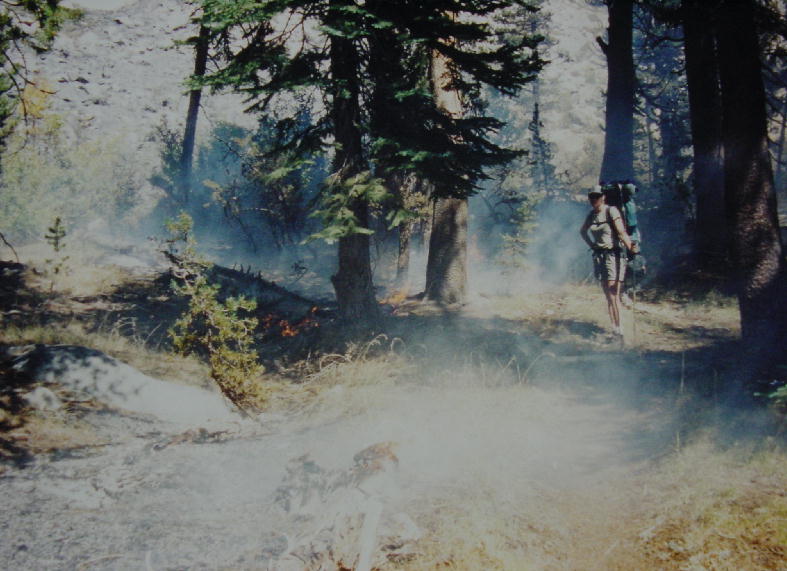
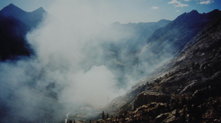
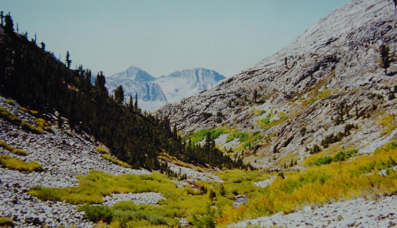
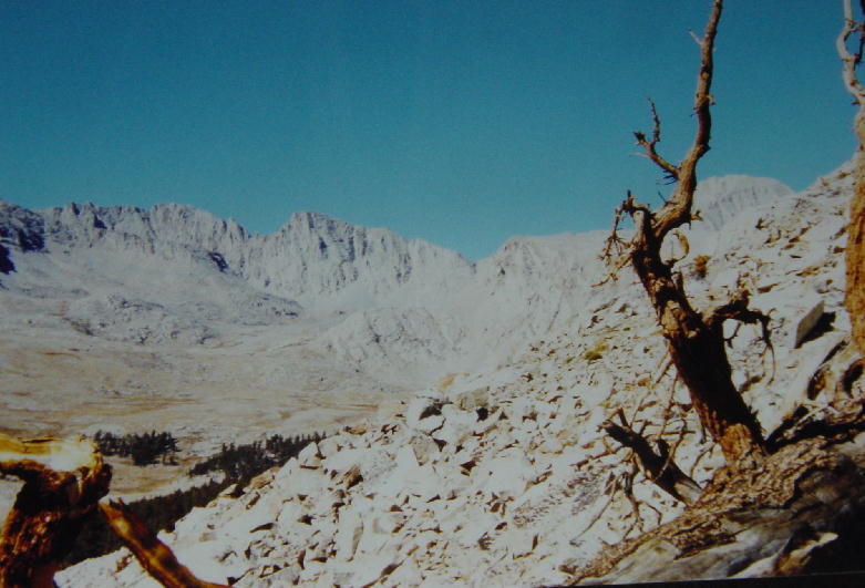
1) Grouse Meadow, this picture turned out well. 2) As you can see this was part of the Palisade Creek fire but this was when we thought this was the extent of it, wrong! 3) This was our view of the valley and the fire from the top of the Golden Staircase.
Friday, September 20, 2002 Day
14, JMT: 11.3 miles 156.0 total
miles
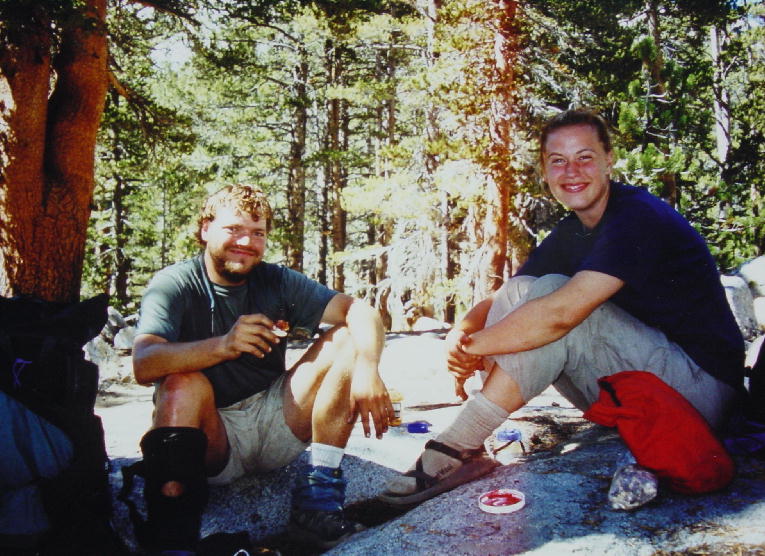
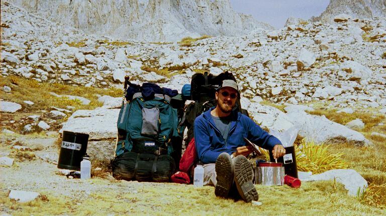
It was 37° at 7:00 AM. It was a long 3.5-mile climb up to Mather Pass, but it was totally worth it. The views were awesome! We reached the pass at 11:00 and rested there with Val and Kevin, a couple young hikers that we met yesterday. They were also doing the JMT. We ended up spending the rest of the day walking with them and talking the whole way. It was probably our easiest day due to having the company of Val & Kevin. Val recently returned from a Peace Corps assignment in Morocco and Kevin just finished his summer as an Outward Bound instructor. They were very interesting people to share time with.
We were also blessed by a very easy section of trail today. The gradient down from Mather Pass and back up toward Pinchot Pass was very gentle. We were really able to cruise. Altogether it probably made for our easiest day to date. We reached Marjorie Lake (11,160’) at 4:15 and stopped 1.7 miles short of Pinchot Pass. We set up our camp, our highest campsite yet. We’ll have a long day tomorrow, but we feel the end approaching with each pass we cross.
We talked this morning about the inner quietude that I get on long hikes. Christine suffers these long days on the trail as boredom. She looks for subjects with which she can keep her mind busy. For example, we’ve already planned what to have on our celebration pizza in Lone Pine when we finish.
Marjorie Lake sits below a tall cliff to the west that put us in shade shortly after our arrival. We put on several warm layers before eating dinner, and we climbed into the tent at 6:00. An hour later we were startled by a thunderous echo of a rockslide coming off a nearby cliff.
Day 14 – Christine
Only five more days of hiking left! Yes, I am totally counting down. Every night I think only so many more dinner's left, etc. Today was a really good day. It was almost a break day with only 11.3 miles and those miles flew by as we got to know Val and Kevin. They were a really nice couple and so nice to get to know, really comfortable, down to earth people. Val is a Wisconsinite also and we drooled over cheese curds and other wonderful things you can get at the Madison farmers market. They are getting off at Kearsarge Pass tomorrow so she is closer to real food than I am. I am just not willing to walk two more days to get on and off the trail. As tired as I am of being dirty, smelly, and as hungry as I am for a good meal I am still glad we carried 11 days of food out of Vermillion and just scheduled to do this whole section in one swoop. Having someone to talk to today was a really good break from normal hiking and has helped to revive my spirit.
Saying the above, and keeping in mind I have five more days of hiking before a hot shower, I was thinking the following tonight as I wiped the dirt off my legs with cold water. I am tired of being dirty! I have gone 14 days without shaving my legs and six days without washing my hair at this point. I haven't seen a mirror for six days. That's a lot of trust in your partner to tell you when something needs to be fixed! These are not records I ever really needed to make.
Well the hike does seem to be working in the weight loss area, my ring slid right over my knuckle and off my finger in my gloves tonight. That's never happened! We have "enough" food but I am at the point were I am always hungry. I mean I am always hungry. I could eat way more than we have to eat. Even though it is working I would not suggest this as a weight loss plan! In my mind as I walk I compare this to basic training. Trust me, there are easier ways to lose weight. Eating moderately and exercising was working just fine for me this year and that is way less time consuming and much easier! This is so hard every day and the hardest part is the walking every day. I got pretty bored with that many days ago.
I don’t have any problem with my pack weight. Part of that is Joe did a really good job of cutting our pack weights. There is nothing that I really wish we had but I use everything I do have and I call that good packing. My pack weight is around 30-35 pounds most of the time. Joe is carrying more weight but I carry any extra water we carry so that is why my pack weight varies a bit. Joe made an interesting point a couple days ago. Before we started this hike, I had lost about 32 pounds since January of this year. So my pack weight isn't any more than what I was carrying around every day before I lost weight. Ugh, I'm so glad we got healthy this year!
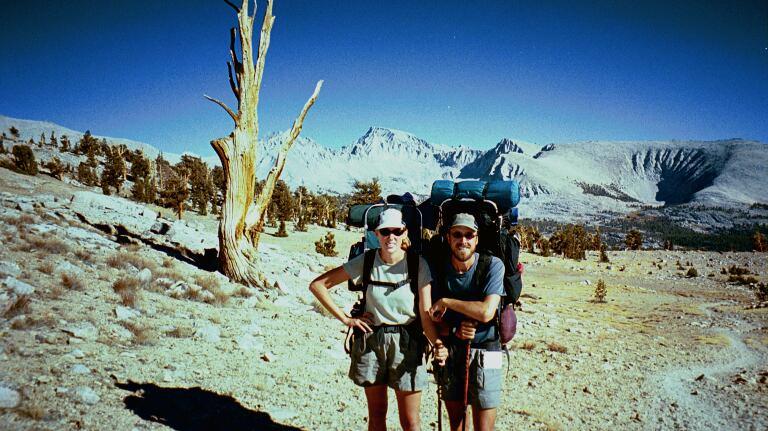
1) Christine and Joe, the view is southeast from Mather Pass. 2) The view of Palisade Range from Mather Pass. 3) Kevin and Val.
Saturday, September 21, 2002
Day 15, JMT: 13.5 miles 169.5 total miles
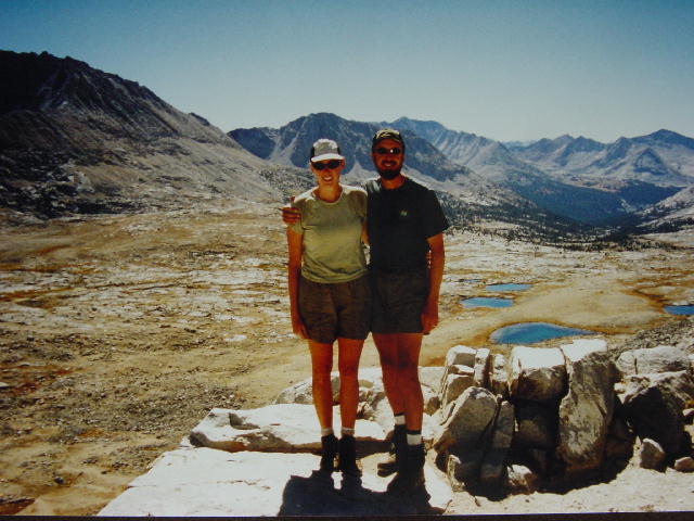
It was 35° at 7:00 AM. We were walking by 7:50 and reached Pinchot Pass (12,130’) after a long 1.7-mile climb. It was another calm and clear day, making it 15 straight days of outstanding weather. We chuckle at how blessed we have been to not get hammered by a High Sierra storm. We had a long hot descent down from Pinchot Pass and were passed by two men and a horse doing most of the JMT. The men were carrying nothing, but the poor horse was burdened with over 200 lbs of gear, including full-sized lawn chairs. This trail is intended for the use of pack animals, but this was a bit extreme. The men could have at least carried daypacks, and they could have eliminated a lot of unnecessary gear. The owner of the horse actually tried to tell me that his horse loved this. You meet all kinds out here.
Christine and I began talking about the last few days of our trip and considered making some changes in our schedule. We are considering camping on the side of Mt. Whitney Tuesday night at 13,500’ to make our final day as easy as possible. This would involve an intense 3-mile climb at the end of the day Tuesday to reach a dry campsite of unknown quality, and be seriously exposed to any negative turn in the weather. We’ll see how things go over the next few days and watch the weather.
We stopped for a break at the suspension bridge over Woods Creek (8547’) and cooled our hot feet in the stream. This always seems to feel good after a long descent. We met a Kings Canyon Park Ranger today out on patrol as we began our climb up to Glen Pass. It is the first time that we have been asked to display our wilderness permit. The ranger was able to give me a little more information about the high campsite that we’re considering on Mt. Whitney. We saw three more deer.
It had been a long day on our feet by the time we reached Arrowhead Lake (10,550’) at 6:00. We settled into our tranquil lakeside campsite and ate a Thai noodle mix for dinner, the heartiest meal in our food bag. We also made some hot tea to lift our spirits. We know we have another big 13-mile day ahead of us tomorrow.
Day 15 – Christine
What a long day, by the end I was kicking rocks and stumbling too much! But it was a pretty day. Only four days left. I am trying to end on a positive note even if I don't want to do this again and I have to say it is exciting to be getting close to the end. We have a really pretty camp spot tonight and we had our last noodle meal for dinner. It was a yummy Thai noodle meal I'd found and it was good! We've had couscous for the past 4-5 nights and while the couscous meals are always really good they just aren't filling enough. Hopefully the noodles will be good energy for tomorrow. After dinner we heated some water for a treat; we enjoyed some hot tea. Wow, it is amazing what a treat that was and how much it cheered us.

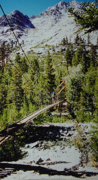
1) Joe with Red Mountain. 2) Fall colors around Wood Creek. 3) Wood Creek Falls. 4) Christine crossing the suspension bridge above Wood Creek.
Sunday, September 22, 2002 Day 16,
JMT: 13.0 miles 182.5 total miles
It was 39° at 7:00 AM and looked to be yet another clear, calm and warm day. It is ironic that two of our coldest nights were at the beginning of the hike when we were still at low elevation. In retrospect, we could have gotten by with the lighter sleeping bags that we had started with, but we’ve been much more comfortable since getting our warm bags at VVR.
We had an easy walk by the beautiful scenery of Rae Lakes this morning before humping it over the very steep Glen Pass (11,978’). We met Kamei at the summit, a Japanese graphic designer doing a very slow hike of the JMT. He is carrying over 65 lbs with fishing gear and a video camera. Kamei was so enthusiastic and was totally enjoying his JMT hike. He was getting everything possible out of his experience. It was great to meet him. He had to quit his job in Japan to come over here and hike this trail.
Christine and I did much better today, though still covering thirteen miles. We descended from Glen Pass and cooled our hot dogs in Bubbs Creek before beginning our ascent of Forester Pass. We stopped at 4:30 at the junction with the Center Basin Trail (10,500’) to camp for the night. We both stripped down and bathed in Bubbs Creek and washed some of our smelliest clothing items. We were able to dry off and get dressed just before the sun slipped behind the west side of the canyon. We both feel pretty good with 36 miles left.
Momentum is building for us to do the high camp on Mt. Whitney Tuesday. I’m amazed that we’re doing this well over all the recent high passes. Christine and I have both been suffering from some chaffing on the inside of our legs, a common condition for long distance hikers. I’m a bit concerned about the degree that the soles are delaminating from her boot uppers. I did everything I could to prepare her boots for this hike, but they were already pretty worn. I hope the soles hold up for a few more days. Our spirits are high.
Day 16 – Christine
It was a fairly easy walk today. It was up and down like every other day but for some reason the miles went by easier for both of us. Maybe the noodles worked! We met some nice people today, the fun Japanese man and a really chatty couple. And then there was the horse. Poor thing, I did feel that the horse was overburdened. This is harsh terrain and they could at least only put what they need on him and not a bunch of extra stuff. Joe and I got into camp tonight after 13 miles with enough sunlight to bath in the stream and I rinsed my shirts out in the stream. The rinsing does seem to help. They are good shirts and I have deodorant but anything would start to smell after eight days of no soap and continuous use.
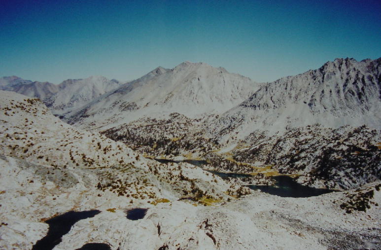
1) A view of Rae Lakes from Glen Pass. 2) Christine and Kamei snacking on the top of Glen Pass.
Monday, September 23, 2002 Day 17,
JMT: 13.2 miles 195.7
total miles
It was 35° at 7:00 AM and another very clear day. We had camped near a large bear-proof food locker that we casually stored our food in overnight. Not all of our food was in the portable bear canisters. We learned that the bear-proof food locker was not rodent-proof. A mouse had crawled into the locker and eaten a hole in our snack bag, nibbling large chunks out of one of my energy bars and a Pay Day. We should have been more vigilant about keeping all the food inside the tightly sealed canisters.
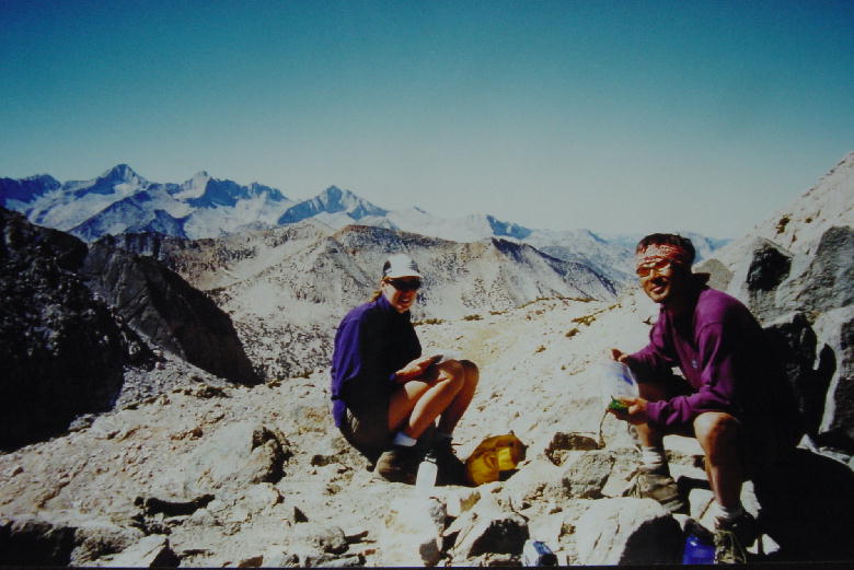
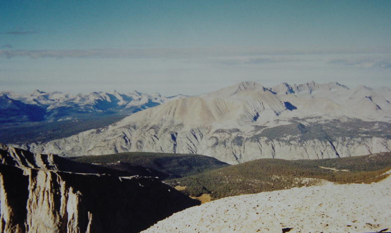
We had a great climb up Forester Pass (13,120’), our highest point to date. We met six other hikers along the way, four of which are also doing the JMT. We reached the pass at 11:30 and hung out to take in the outstanding views. I enjoyed passing some time speaking to Drew on the way down. The group dynamics among those six hikers had to be very interesting. We passed from Kings Canyon National Park into Sequoia National Park as we crossed the pass.
Christine and I cruised across the wide basin south of Forester Pass and pressed all the way to Wright Creek (10,790’) for the night in order to make tomorrow’s approach to Mt. Whitney as easy as possible. Christine was very quiet today. I could only guess that she was probably contemplating the completion of this endeavor. This has been the most physically demanding event in her life thus far, and she must be awfully impressed with how she has performed, body and mind—I know I am. We’ve done 40 miles over three high passes in the past three days. We are awfully close to the end.
Day 17 – Christine
Two days of hiking left! Today was our last 13-mile day; we've done three in a row. I climbed Forester Pass with no problem. I move pretty slowly but my body has really delivered. My heart never pounds, my breath never gets real fast, and my legs climb up and over with little complaining. I just try to move carefully. It helps my knees, and my boots are barely going to make it. I need to try to kick rocks as little as possible.
Ok, now we are going to get a little personal. This morning I went to dig a hole to go to the bathroom. I found a nice tree without too many rocks below and I was horrified on my first dig to turn up a dirty tampon, pad, and all the wrappings! Someone needs to slap that woman and good! No one should be out here without the knowledge that they have to carry out any garbage they bring in, and to come out here with that knowledge and to ignore it is NOT acceptable. Nothing should be buried except human waste. A little lesson people, if it doesn't decompose in the toilet, it is not going to decompose in nature. I am now carrying out that woman's garbage because I couldn't fathom leaving it there.
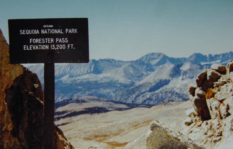
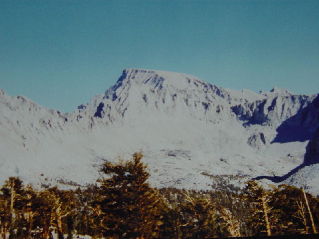
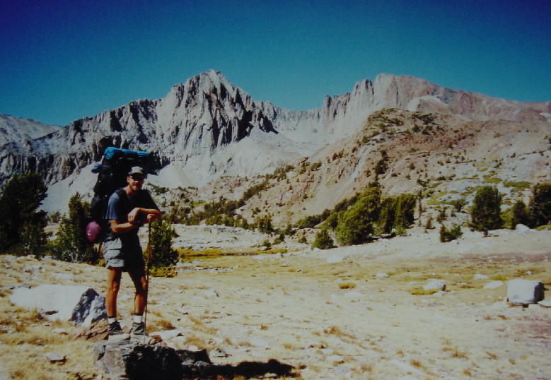
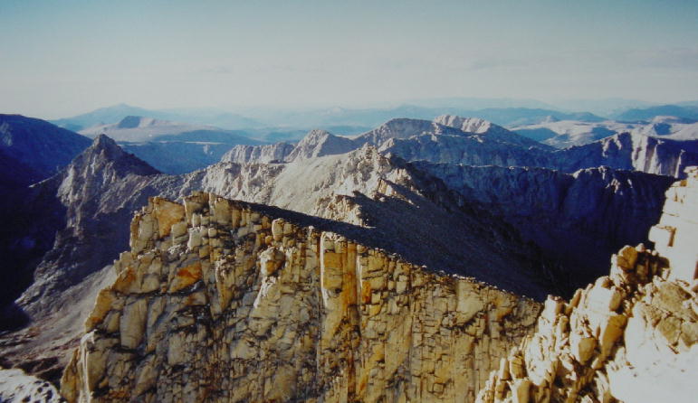
1) South-facing view from Forester Pass and the sign at the pass. 2) Christine on Forester Pass, the view is south. 3) Looking back up Forester Pass from the south. 4) Joe and Christine in front of our first view of Mt Whitney. 5) A close up view of Mt Whitney from the same viewpoint as number 4.
Tuesday, September 24, 2002 Day
18, JMT: 10.5 miles 206.2 total
miles
It was 32° at 7:00 AM and we were walking by 8:00. Clouds moved in by 11:00 and threatened us with the first real signs of a weather front. I began to get anxious about our plans to camp high on Mt. Whitney tonight. I took a short side trip to seek out weather advice from the Crabtree Ranger Station, but the ranger was out on patrol. We stopped around noon at Timberline Lake and prepared for bad weather. We repacked our packs to ensure that our clothes would stay dry in the event of rain. We even put on long pants to hike in, protecting us from the wind chill.
The first dark front blew through giving us hope that the weather front was poorly organized, but there were many more clouds building up to the west of us. We got to Guitar Lake (11,483’) at 1:00. This was supposed to be our campsite on our original schedule. We would have had a marathon 15-mile day for our last day tomorrow, beginning with a 3000-foot climb to the summit of Mt. Whitney. Our revised plan had us hiking three more miles to knock out more than 2000 feet of that climb before quitting today.
We sat at Guitar Lake and watched intermittent dense cloudbanks drift through. We pumped a whole lot of water and ate our last supper, quite early. Our high camp would be dry, so we would need to carry all the water that we would need for the rest of the day as well as for the hike to and from the summit tomorrow. We filled every container we had with water and decided to go for our high camp.
We left Guitar Lake at 2:00 and covered the elevation in just under three hours. It was a very slow and steady pace. Our packs had been getting lighter with each day as we ate down our food stores, but the added water weight that we carried up the mountain reminded us of how heavy are packs had been just a week ago. We were very pleased with the campsite perched on the side of Mt. Whitney’s west face. We had a light flurry of snow fall on us briefly during our climb, but otherwise the weather continued to blow through. It appeared that the mountains to the south were getting more precipitation, but it was hard to tell.
We prepared for tomorrow as we continued to watch the sky. We put on all our clothes to stay warm so that we could watch the most amazing sunset. We crawled into our sleeping bags at 7:00 and hoped to stay warm for the night.
Day 18 – Christine
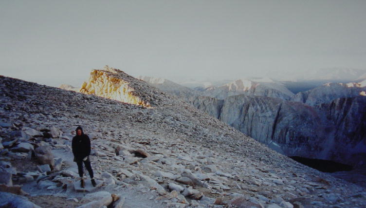
We are both excited to be done tomorrow. Clouds came in today and we prepared for rain but we kept an eye on them and went on with our plans to camp at 13,500 feet. A group that had been behind us stayed down at Guitar lake. They were there all afternoon in the shade while we climbed the mountain and I am so glad we didn't stay there. It gets cold fast in the shade and it would have been a long afternoon. Also, if it does storm we can always skip the summit and just head down the other side and get off the mountain. They still have to climb out. I climbed really well again today and I have to say I'm proud to be up here and to be one day away from being done. We covered the miles well today and got up here by 5 P.M. Now we are just trying to stay warm. It is cold but we are watching for a sunset since we have clouds. We got up here and munched all the good snacks we had left except for one candy bar that we are saving for the summit tomorrow. After that we'll only have energy bars for the way down. We are both excited about hot tea in the morning before the summit.
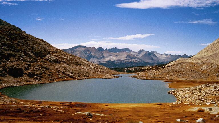
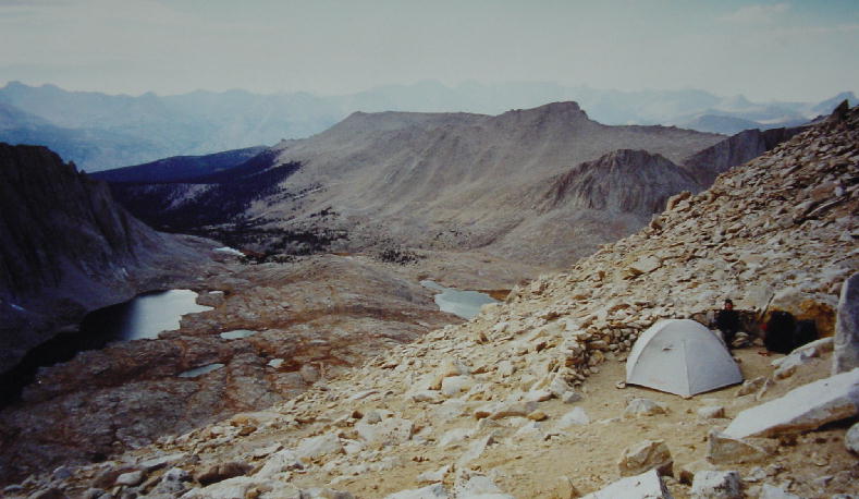
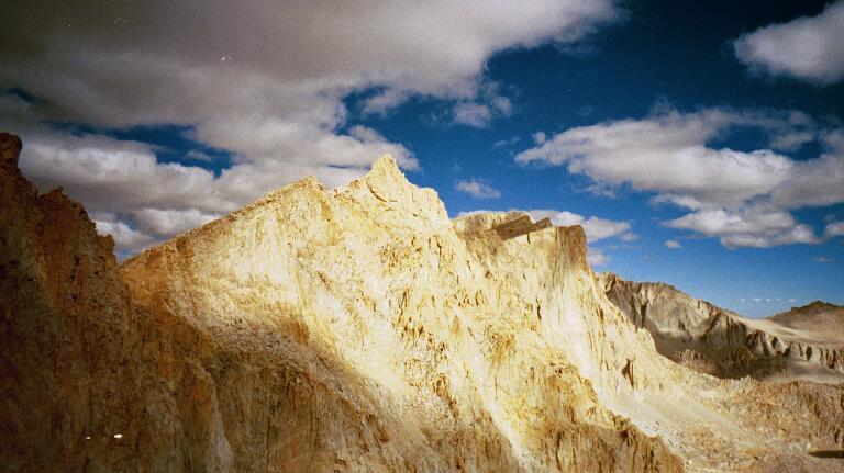
1) A view of the west face of Mt Whitney in Timberline Lake. 2) Joe makes our last hot meal on the trail. 3) Guitar Lake from above. 4) A view of Christine and the tent at 13,500 feet on Mt Whitney. 5) A view of the clouds as they start to lift. 6 and 7) The sunset under the clouds.
Wednesday, September 25, 2002 Lone
Pine, CA Day 19, JMT: 12.1 miles
218.3 total miles
I woke shortly after midnight and did not sleep much after that. I’m not sure what it was, but I’m certain that the anxiousness of finishing was at least part of it. I kept checking my watch until 5:00 AM finally rolled around. I sat up and fired up the stove for our planned cup of hot peppermint tea (caffeinated). This is the only morning on the trip that we used the stove. I heard the voices of a couple men hiking up the summit trail above us shortly after 5:00. I later learned that they reached the summit at 6:00 AM after departing the Whitney Portal parking area at midnight last night. That is a serious climb from about 8000’ at Whitney Portal to the summit of Mt. Whitney (14,498’). They were from Mammoth Lakes, a nearby ski area where they were already pretty well acclimated to the altitude. The moon was still nearly full, and it illuminated the ground to the point where flashlights were unnecessary for a night hike, making the climb that much easier for these guys.
Christine and I packed up most of our gear, but left it in the tent. I donned a daypack that is a removable component of my backpack and we began our attack on the summit at a bit past 6:00 AM. Early signs of dawn were painting the sky in faint colors as we clung to the western side of Mt. Whitney’s ridgeline. We passed beneath the peaks of Mt. Muir, the Pinnacle and the Needles. The sun had broken the eastern horizon by 7:00 and snuck through the gaps between the peaks. We were both bundled up in several layers against the morning chill, though the persistent wind from the west seemed to penetrate through our clothing. We met the two men from the above paragraph on their way down from the summit. They told us their story and informed us that we would have the summit to ourselves.
We reached the summit of Mt. Whitney at about 7:30. It had not been a difficult two miles, only having to gain 1000’ final feet of elevation. Christine and I strolled to the summit and quietly absorbed the moment of triumph and accomplishment. I felt like we were simply incorporated into a larger state of grace that many believe is a constant element of wilderness this grand. We took some summit pictures and huddled out of the wind to avoid succumbing to the chill. Even though it was quite early, we shared the Reese’s Peanut Butter Cups that we had reserved as our summit treat. We signed the summit register and prepared for our long descent of over 6000’ in about ten miles. We noticed that Tony and Alexa, as well as the large group Brits had all signed the register yesterday. It was pleasing to know that all these people reached the summit.
We began seeing other hikers after we were about a mile from the summit. We reached our campsite from last night by 9:15 and spent about a half hour getting all our gear together and finally began to head down the mountain in earnest. We were amazed by how many people were coming up the mountain from the Whitney Portal area. There are several camps stretched out along the approach trail at various elevations that allow most hikers to gradually acclimate to the altitude over several days. The highest camp from the east lets climbers get to 12,000’, and then attack the summit from there with daypacks. Most of the people that we saw were departing from this high camp. Many of them inquired about our hike since we were coming down so early and wearing such obvious grins of success. We realized quickly that we would never get down the mountain if we paused to speak with everyone we passed. Christine counted over 50 people coming up the mountain today.
We descended the 102 switchbacks to reach the high camp at 12,000’ and then gradually began stripping layers of clothing as we escaped the cool chill of the summit and sunk into the heat of the day. We began to get concerned that we were coming down the mountain too early, because we hadn’t passed anyone else that was also descending. We had hoped to meet some people on our way down that could give us a ride back to our RV south of Lone Pine, about 20 miles from the trailhead at Whitney Portal. We finally met a German couple very near the bottom, and I was persistent in soliciting a ride. They weren’t sure that we would all fit in the car with our gear, but they were willing to give it a try.
We reached the Whitney Portal parking area at 2:30 and somehow managed to squeeze everything into their rental sedan. Christine and I were buried under three large packs in the backseat, and couldn’t even see the road ahead of us, but we were elated at being so fortunate to get a ride right away. We were back at the RV park in Lone Pine shortly after 3:00 and just reveled in our good fortune. The campground had a well-stocked convenience store, so we immediately bought some beer, chips, salsa, and cheese dip. The RV survived being idle for three weeks, other than a mild infestation of sweet ants.
We slowed down to enjoy our good fortune and began to give into our whims. We enjoyed our beer and snacks as we stripped out of our smelly hiker clothes and prepared to get clean. Christine took advantage of the high quality showers provided by the campground so that she could enjoy a long hot shower. I was satisfied to use the RV’s shower. We ended up clean, relaxed and in street clothes. We were both shocked when we stepped on the scale. We had each lost over 15 pounds on our hike. I was very surprised by this number. I knew that we weren’t eating as much as our bodies were burning, but I hadn’t felt like it would result in such an extreme weight loss. We had fun feeling thin in all of our clothes.
Christine checked e-mail, which took a while since she had to download three weeks worth of messages. She learned that her final masters project required some more work. She half anticipated this since she had to complete it a month early for our hike, but it still came as a let down. She’ll be preoccupied with finishing this over the next week.
We drove into Lone Pine and went to the town pizza parlor for dinner. After an order of garlic cheese-bread, two salads, a pitcher of beer, and a pizza with all my favorite toppings, we were both well on our way to regaining some weight. We went back to the campground and crashed in bed while watching some of our favorite programs on TV.
It is interesting to reflect now on the good
fortune that we enjoyed over these 19 days.
We saw many deer as I noted in the daily entries, but we never
encountered a single bear. We
carried over 5 lbs worth of bear canisters and never complained about it.
Also, we had no problems with mosquitoes. We knew that the mosquitoes were
horrible in this area earlier this year and we both suffered only one mosquito
bite each.
Day 19 – Christine
Finished! You can't imagine the smile on my face all the way down. The summit was wonderful this morning. We had it to ourselves and it was totally like being on top of the world! We were above all the mountains around us. You could see mountain ridge after mountain ridge all around. Very satisfying. We were both so glad to have camped up there. Experiencing such a great sunset and sunrise on top of the mountain was a perfect end to our trip. I can't even believe we had 19 straight days of perfect weather.
We passed over 50 people climbing to the summit as we floated down the mountain. I was so happy and we were so focused on beer, food, and showers! People wanted to talk to us but we didn't stay in one place too long as we wanted down. But I was more than happy to share with people my accomplishment. People kept saying, "You look too fresh to have hiked so far." I guess they couldn't get beyond my smile to see the dirt all over my clothes and hopefully I did a good job cleaning. When we got to the campground we were just so grateful. We had a beer and chips first, even before a shower. But that shower was amazing. They had great showers at this campground and I just used all the hot water I wanted. I think I was moaning out loud! I have to say, looking in the mirror was a shock. I haven't seen a mirror for 10 ½ days so I haven't really seen the weight loss. Wow! I'm just going to revel in being skinny for a couple days because I'll gain some of it back as soon as I rehydrate. But right now the scale shows about 16 pounds less than when we started!

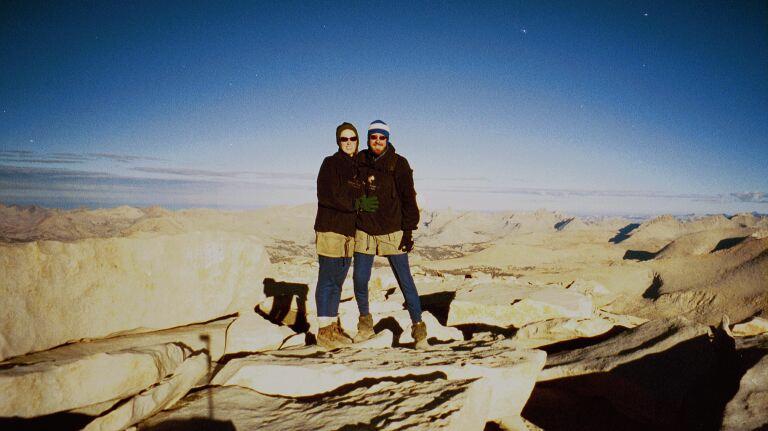
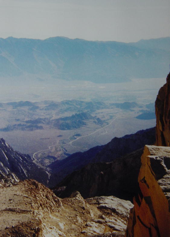
1) Walking up to the summit at 7 AM. It was very cold but exciting. 2) The trail goes right past those windows and we'd peak into the sunrise on the other side. 3) The plaque on the top of Mt Whitney. 4) Christine and Joe on the top of the world. 5) This is Mt. Muir from the summit trail on our way down. 6) The East side of the summit trail. 7) At this point Joe and I are less than 2 miles from the end! I couldn't believe how skinny my legs looked when I saw this picture. 8) A view of the Western Divide from Mt Whitney. 9) A view south of Mt Whitney.
Please find the map and profile of the John Muir Trail by clicking here.
Thursday, September 26, 2002 Bakersfield, CA
We both slept in after stuffing ourselves with food last night. We took care of a few e-mails and some phone calls before packing up. We had a few errands to run before working our way back around to Yosemite to retrieve Christine’s bike. We drove back into Lone Pine in search of a JMT patch and some sweet ant killer. We noticed some backpackers hitching a ride south and we slowed down for a closer look. Sure enough, it was Tony and Alexa, the two Brits that we met our first night in the JMT. It turns out that Greyhound had stopped servicing Lone Pine several years ago, and they had counted on catching the bus to L.A. We offered to take them as far as Bakersfield, but it meant spending the day piddling around with us.
Tony & Alexa hopped in the RV and joined us for lunch at the Mt. Whitney restaurant in Lone Pine. I found a JMT patch and the ant killer, and then we drove farther north to Independence to get the lightweight sleeping bags that we had shipped out of Vermillion. Coming back from Independence, we stopped at Manzanar National Historic Site, one of ten War Relocation Centers established after the attack on Pearl Harbor that housed nearly 120,000 Japanese Americans during WWII. Over 11,000 were relocated to Manzanar between 1942 and 1945. Very little remains on the site, but a driving tour through the Center reveals hints of what life may have been like for these people. In brief, the creation of Manzanar and its kind were a shameful part of our history, and it is good to learn more about these events lest we are doomed to repeat them.
The rest of the afternoon was a very chatty ride south on highway 395. We turned off to take the scenic route past Lake Isabella and down the Kern River Canyon to Bakersfield, but most attention was spent on catching up with each other about our respective JMT experiences. Tony and Alexa had pressed ahead of us because their schedule had them finishing a day ahead of us, though we later learned that we reached Whitney Portal just a few hours behind them yesterday. They did indeed summit Whitney on Tuesday, but then only descended to the high east camp at 12,000’ just 2.2 miles from our high west camp at 13,500’.
We really enjoyed their company and made a point of offering them any help that we could. We went to the Amtrak Station in Bakersfield and confirmed that they could get to L.A. tomorrow, then we got them a motel room near the campground we chose for the night. We gave them time to clean up and later picked them up for dinner. A simple, but satisfying meal at Denny’s was our best choice in the area. It ended up being a fine way to finish the day. We made plans to give them a ride back to the Amtrak Station in the morning, and then called it a night.
By Christine: It was such a joy to see Tony and Alexa today. I had thought of them often and would always ask northbound hikers about them, so I knew they were still in front of us. They are both such warm, wonderful, active people. God was watching all of us on this journey and I am so happy that we could help them out and make sure they will be able to make their plane on Saturday with no problem. Hopefully we will see them again someday.
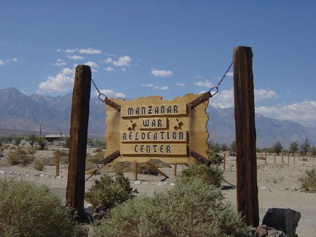
There wasn't much to see at the War
Relocation Center but we learned a lot of good information from the handout.
Friday, September 27, 2002
Bakersfield, CA
Christine and I crunched through some household business issues this morning with the aid of the phone connection at our campsite. We then went and picked up Tony and Alexa from their motel to give them a lift to the Amtrak station. They fly back to England tomorrow out of L.A. I had chosen a film processor to develop our film from the JMT and the disposable cameras we used at Burning Man. The processor committed to having everything developed and saved on PhotoCD’s by 5:00, so we had an afternoon to kill. We went to a nearby mall and did some shopping and caught a matinee showing of “My Big Fat Greek Wedding.”
We were disappointed to learn that there had been problems with our film. They were unable to get two of the rolls onto CD’s. And later examination of the CD’s showed very poor exposure levels on many of the pictures. We decided to leave the negatives there and have prints done overnight in hopes that they might turn out better. This meant that we would spend another night here in Bakersfield. It is not a bad town other than having very few grocery stores.
Saturday, September 28, 2002 Sanger, CA
We unhooked from our campsite and stopped to pick up our pictures on the way out of Bakersfield this morning. The prints were an improvement over the PhotoCD images, but I am still disappointed overall. The skies were very overcast and the temperatures were in the seventies as we made our way north to Sequoia National Park, the nation’s second oldest (est. 1890). Even though we had walked through much of the park on the JMT, we hadn’t seen any of the giant trees from which the park gets its name.
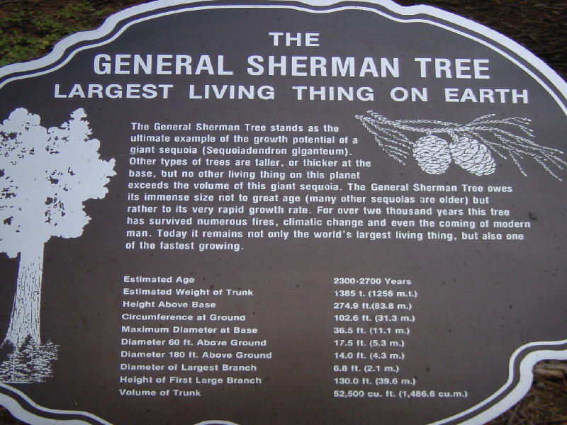
The giant sequoia tree grows on the moist western slopes of the Sierra Nevada between 5000 and 7000 feet in elevation. In volume of total wood the giant sequoia tree stands alone as the largest living tree on earth. At least one tree species lives longer, one has a greater diameter, three grow taller, but none is larger. The General Sherman tree is the largest living sequoia at 275 feet tall and about 2500 years old. The trunk of this tree weighs an estimated 1385 tons and has a circumference of 103 feet at the ground.
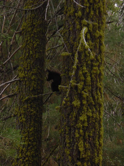
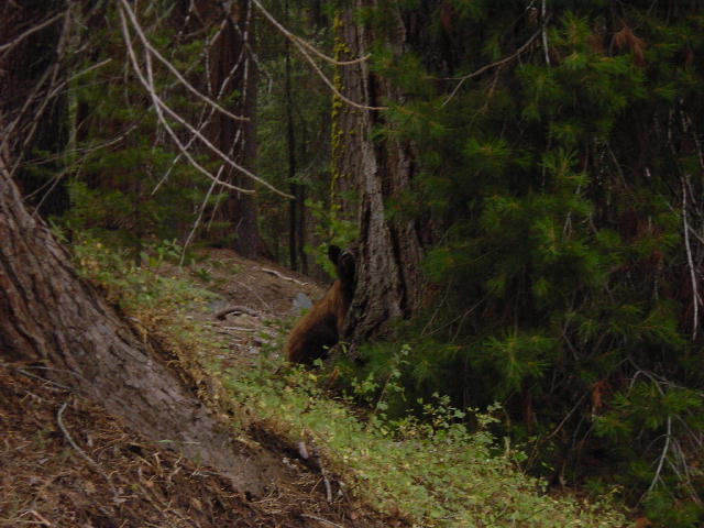
We went for a walk in the Giant Forest grove to enjoy the greatness of these trees. I still prefer the overwhelming presence of the coastal redwoods because of how they grow so close together, but the giant sequoia is no less grand. Christine and I were taking a well-established walk along an interpretive trail when we were suddenly upon a mother black bear and her cub. The cub was very small and clung to a branch 15 feet off the ground, but the mother was quite stoic. We were hesitant to continue down the trail because of how dangerous a mother bear can become when she feels that there is a threat to her young. This mother however, was quite small herself and was content to sit by and wait for us to pass. We walked by clapping our hands loudly and talking firmly, and we got little reaction at all. We spent nineteen days in the wild on the JMT and didn’t encounter a single bear, and here within sight of a road was a very casual encounter with two—go figure.
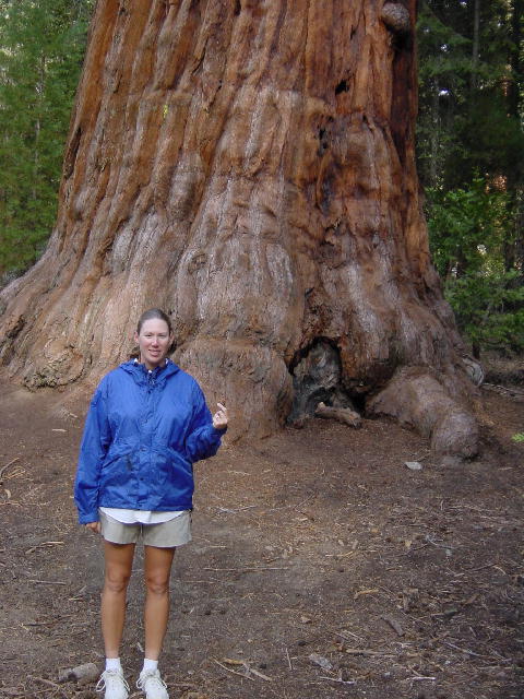
1) Behind me is a large Sequoia tree and I
am holding one of it's cones. It seems the taller the tree the smaller the
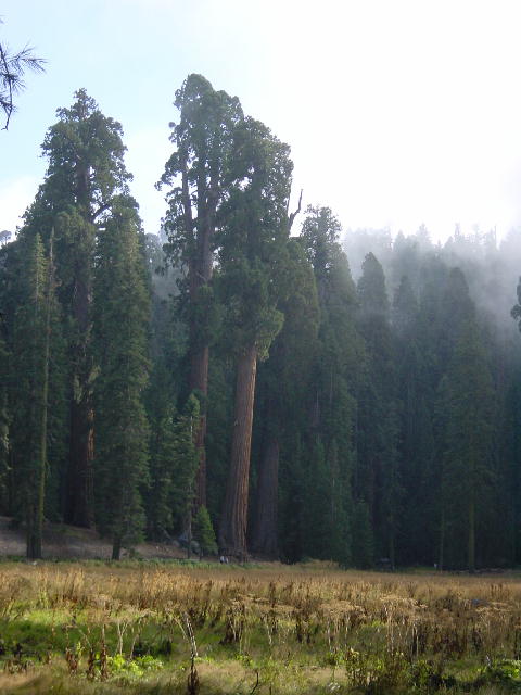
cone. 2) The large trees that go above all the others are Sequoia's.
3) This information can give you some idea of the size of these trees.
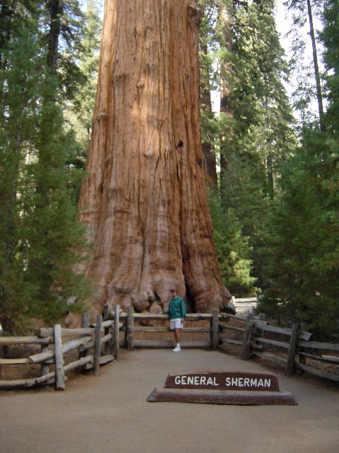
4) This is the General Sherman tree. 5) The baby bear is up in the
tree. 6) Mother bear peering at us from behind another tree.
Sunday, September 29, 2002 Yosemite National Park, CA
We slept in this Sunday morning before driving into Fresno for a few errands. We drove up Highway 41 to Yosemite National Park, entering from the southwest side. This is the best way to enter Yosemite Valley, getting an aerial view of El Capitan with Half Dome looming in the background. We were surprised by how many people were in the park this late in the season, but it is still the weekend. We had to put our name on a waiting list to get a campsite, but we were able to get one.
I recovered Christine’s motorcycle with no troubles, save the thick layer of dust caked on all the bike’s surfaces. We went for a few-mile walk to return the bear canisters and then set to restoring order to the RV’s garage. This meant washing Christine’s bike, sorting through all the camping gear and stowing everything in its place. We wrapped up in time for dinner. We celebrated tonight by grilling some filet mignon and asparagus. Christine whipped up an old favorite staple of egg noodles with bread crumbs, and we broke out a bottle of Lemberger wine that we had been saving from our visit to the Whidbey Island Winery.
Christine went all the way by creating an excellent dessert. She sliced a couple of ripe pears and caramelized them in a skillet with brown sugar, brandy, walnuts and cranberries. She poured the heated concoction over a couple scoops of Ben & Jerry’s vanilla ice cream to complete an outstanding dessert. She made the whole thing up from ingredients she had on hand. Every good Wisconsinite has a bottle of brandy in the cupboard.
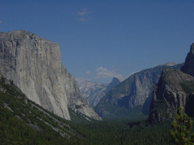
El Capitan is on the left of the picture and Half dome is in the back right of the picture.
Monday, September 30, 2002
Watsonville, CA
We got started this morning with a three-mile walk up to Mirror Lake, which is just a sandy meadow this time of year. We then left Yosemite National Park and pointed the RV west toward the coast. We drove through Merced on our way to Gilroy, Garlic Capital of the World. We had hoped to make it to Gilroy for their annual Garlic Festival the last week of July, but we were traveling with our friends Doug and Teresa in Montana at the time. We stopped in The Garlic Store in town, but didn’t stay for long.
We continued west toward Monterey Bay and stopped for the night at a nice city park in Watsonville. It even had phone hookups at the site. We settled in for a quiet evening and Christine put together a great spinach lasagna for dinner. I climbed in bed early with symptoms of a cold.