| The Lustik Travel Home Page |
June 21 - 30, 2001
Thursday, June 21, 2001
Hopewell Cape, New Brunswick
We had a pleasant drive through New Brunswick today. We stopped at the visitor center as soon as we crossed over from Maine, and received an abundance of well-organized information. We drove along the serene beauty of the Saint John River through Fredericton, the provincial capital. We dropped down to the Bay of Fundy to visit the Fundy National Park. This began our exploration of the interesting tidal phenomenon associated with the bay.
The Bay of Fundy is home to the world’s greatest tidal fluctuations. In some points along the bay, the water level changes an average of forty feet between high and low tides. This creates some spectacular scenery. My curious mind was eager to understand what makes the tide fluctuate so much here. Now all of you readers may benefit from my curiosity. Most people understand that the primary cause of high and low tides is the gravitational attraction of the sun and moon pulling on the earth’s oceans. The strongest of these forces is the moon, resulting in high tides about twice a day. This gravitational pull accounts for a sea level change of about three feet, all by itself.
The next tidal factor is the shape of the ocean floor. Tidal fluctuations vary from region to region based on how steady the ocean floor slopes toward the coast. A gradual slope creates a saucer effect, which amplifies the effect of the tide. A steep undersea wall just offshore serves to minimize the tidal effect.
The Bay of Fundy introduces two additional factors that influence the tidal change. The first factor relates to a condition known as the basin effect. Saucer-shaped basins of water like the Bay of Fundy have their very own ‘back and forth’ movement of water. Similar to water sloshing back and forth in a bathtub, large basins like the Bay have an independent tidal cycle.
The second factor for the Bay of Fundy is that its independent sloshing cycle coincides with the timing of the global tidal changes. This creates a complementary harmonic increase in the amplitude of the tide change in the Bay of Fundy. For me, this is an enlightening experience marrying physics and geography. I was pleased to get to see this. For those of you uninterested in such scientific revelry, I’m sorry to say that there’s more to come tomorrow.
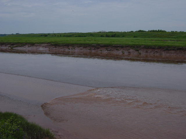
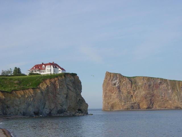
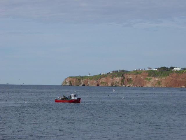
Tonight we are camped near Hopewell Cape where there is a park dedicated to the tidal event. The Rocks at Hopewell Cape are an outcropping of eroding coastline that gets halfway engulfed by the high tide. At low tide we were able to walk (actually run, in order to evade the mosquitoes) beneath the rocks on the floor of the Bay. We took pictures of the rocks at low tide. The high tide water line is very visible in these pictures.
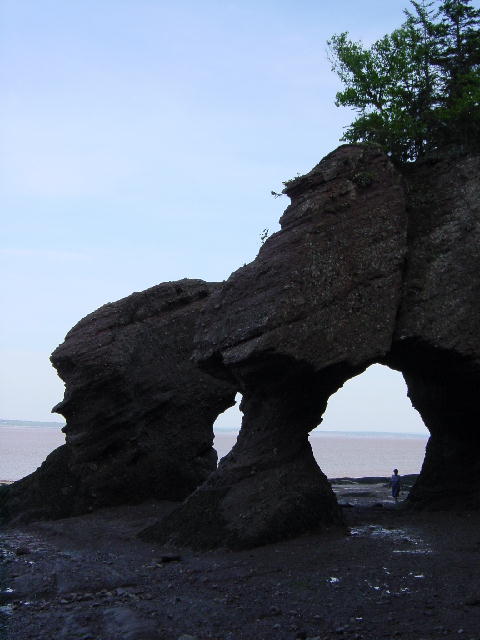
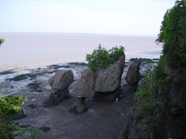
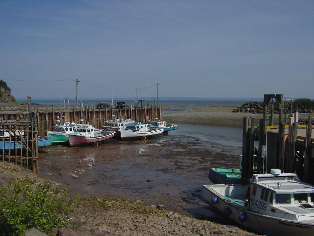
1) Hopewell Cape at Low Tide. This is taken standing on the bottom. 2) This is taken from the top edge looking out over Hopewell Cape. 3) Boats at low tide.
Friday, June 22, 2001
Baddeck, Nova Scotia
This morning we drove into Moncton, New Brunswick to witness another phenomenon resulting from the amazing tides of the Bay of Fundy. We got to watch the tidal bore of the Petitcodiac River. The Petitcodiac River is little more than a muddy stream about twenty miles upriver from the Bay of Fundy. This little stream however, sits in a deep wide riverbed that portends the effect of the tide. Twice a day the rising tide comes upriver so quickly that it creates a wave as it reverses the flow of the river by shear force. This wave is referred to as a tidal bore.
We waited for an hour to watch this phenomenon take place. It was easy to believe that nothing ever really happened to this unassuming little stream as we waited impatiently. Finally the sea birds gave us our first indication of the approaching bore. The birds feed on sea life that gets washed up into the river shallows by the encroaching tide. The tidal bore today was about a foot high and moved against the stream at about 5 mph. In a quick few minutes the tidal bore overtook the river in front of us and then began filling the riverbed to its banks. If we waited another hour the river would rise ten feet right before our eyes. I was very pleased with the observation of this event. We took a sequence of four pictures that illustrates this effectively.
While still in Moncton I humored myself with exploration of one more scientific anomaly. There is a hill in Moncton known as Magic Mountain. You get there by driving up Magnetic Road. The mystery of this anomaly is that cars supposedly travel up this hill unaided by the engine. For two dollars we decided to give it a try with the RV. I was willing to believe that a strong magnetic deposit may exist in this hill, so I asked the attendant whether we needed to be concerned about damaging our computers by exposing them to such a strong magnetic force. I was assured that our computers were not at risk … this puzzled me.
The actual hill that exhibits the magic pulling effect is merely a hundred yards long and only a very slight incline. The magic here is merely an illusion. The hill that the RV is pulled up is actually a downward incline. The stretch of road is so uniquely situated amongst other inclines that it only appears to be uphill. So, no magic here folks.
We finally got out of Moncton and headed toward Cape Breton Island of Nova Scotia. I had never been to this part of Nova Scotia and was looking forward to the visit. We found a centrally located campground on Cape Breton and checked in for two nights.

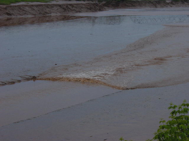

This series shows the Moncton tidal bore. 1) The almost dry river. 2) The tidal bore coming in. 3) The tidal bore moving past us. 4) The full river.
Saturday, June 23, 2001 Baddeck, Nova Scotia
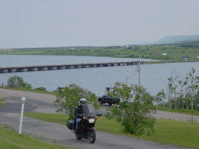
We awoke to gray skies this morning, but proceeded with plans to motorcycle around the Cabot Trail loop on Cape Breton. This road is a very scenic drive that mostly follows the coastline. Christine and I headed out onto the 200-mile loop. The road surface was similar to many other secondary roads in the Maritime Provinces. By that, I mean that the road had either just recently been resurfaced, or was long overdue for being resurfaced. The poor sections required a lot of attention while on the motorcycle, and Christine decided that she wasn’t up for doing 200 hundred miles of this. We stopped for coffee along the coast and decided that she would turn back to get more writing done on her two term papers due next week, while I would continue on alone and complete the Cabot Trail loop.
The skies cleared a little along the coast facing the Gulf of Saint Lawrence. The road travels a beautiful line through small towns and along steep bluffs and cliffs that make up the coast. I climbed to higher elevations as I crossed the island through Cape Breton Highlands National Park to the coast along the Atlantic Ocean. The temperatures were much cooler there, but still great riding. The sky threatened with some sprinkles, but never really rained on my ride.
I returned to find Christine hard at work on her papers as we spent another evening inside, out of the blood-sucking range of the mosquitoes.
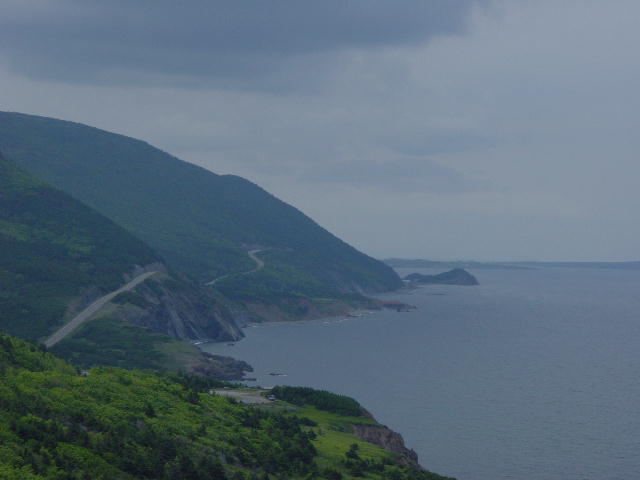
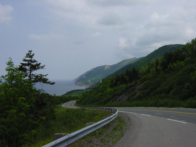
1) Christine coming in to stop for coffee. 2) The road already ridden on the Cabot Trail. 3) The road ahead on the Cabot Trail.
Sunday, June 24, 2001
Kouchibouguac, New Brunswick
We made today a travel day as we returned west along the same route that we traveled earlier. We decided to skip Prince Edward Island for three reasons: the weather was poor, PEI is suffering an advisory to boil all their water, and we are a little behind schedule to arrive at Christine’s parents on Friday.
Tonight we are camped outside the Kouchibouguac (coo-she-boo-jwok) National Park. We have plans to drive through there tomorrow.
Monday, June 25, 2001 Percé, Quebec
We ended up skipping the National Park this morning so that Christine could get three hours of internet time on line at an Access Center in Bathurst, NB. We then crossed into Quebec at Campellton, NB and enjoyed our drive along Chaleur Bay out to the Gaspé Peninsula.
The drive around the peninsula is all coastal with pleasing views of the shoreline and the inland mountains. We really felt like we were in a foreign country today as Quebec is a very French province. I had a first experience today as I was pulled over for the first time in the RV for a speeding violation. I had been traveling behind a slow-moving minivan towing an oversized camper-trailer when I finally lost my patience and took advantage of a designated passing zone to get in front of it. Now keep in mind that our RV doesn’t exactly sprint in passing mode. I dropped out of overdrive and put the pedal to the metal. The reaction was slow, but noticeable. The passing space was short and narrow, so my attention was on gaining speed, and clearing the van and trailer. I had no notice of the police car parked up ahead.
I had only just returned to my lane after passing the slowpoke when the police car began flashing its lights and waved me over. Oh s---! My misfortune! I pulled over and prepared my wallet for the officer. He walked up to the window and began speaking to me in French. I asked if he spoke English and he immediately pulled out his pen and wrote two numbers in the palm of his hand: 80 and 104. He began spewing in French, though I knew what he was saying. The speed limit was 80 km/hr, and he clocked me at 104 km/hr. In my silent disappointment I reflected on the poor performance of my RV at passing speed (64 mph). After the officer finished speaking I went into an intense explanation of how I finally got a chance to pass this slow moving traveler that refused to yield to faster traffic. The officer listened to me attentively and then released us to continue our trip. No ticket … nothing. Christine is convinced that the officer anticipated nothing but grief from my intensity and the language barrier, and thus called it quits before it got out of hand.
We continued on up the peninsula to the touristy town of Percé. The late afternoon light created splendid views of the cliff formations. We found a great campsite right on the waterfront and settled in for the evening. Christine even treated me to a home baked pie, though I can’t have any until tomorrow. It’s a peach cheesecake pie that needs to set up overnight.
I haven’t spoken much about the heat wave that eastern Canada is experiencing. With temperatures in the mid to upper eighties and high humidity, most residents have been complaining of the discomfort. The most annoying side effect of the weather was its conduciveness to swarming mosquitoes. Here in Percé we are enjoying our first real break from the weather. Cooler and drier conditions make this popular Canadian vacation spot the perfect place to be right now.
By Christine: Just a note. We didn’t really skip the park because of my need for Internet time today; actually we missed the entrance and didn’t want to turn around. Either way, the Internet time was much appreciated.

1) Our camp spot tonight. 2) Not a bad view???
Tuesday, June 26, 2001
St-Roch-des-Aulnaies, Quebec
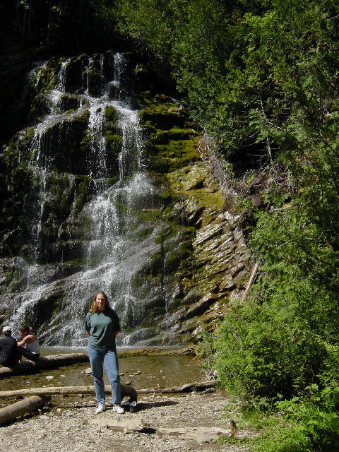
Today was a very long drive. Very long! We got up pretty early and went for a nice walk around the town and out on the wharf. We were being greeted with such a lovely day. We drove on up to the tip of the Gaspé Peninsula to visit the Forillon National Park. At the far eastern tip of the province here, the land gives away to the sea with steep sheer cliffs and mountainous terrain. We stopped in the park for a short loop hike to visit a waterfall.
Forillon National Park contains the final miles of the International Appalachian Trail (IAT). The IAT begins at Mt Katahdin in Maine, the end of the original AT, then continues a sweep of several hundred miles through the center of the Gaspé Peninsula until it reaches the northeast terminus at the very tip of the peninsula in Forillon National Park. The peninsula has several three and four thousand-foot peaks, and appears to be a demanding addition to the original trail in the U.S.
After visiting the park we got back under way in the RV covering about one hundred very difficult miles over very bumpy and hilly roads. The hills had incline rates of as high as 19%. We moved very slowly through this grueling section until the road finally leveled out and the pavement improved near Ste-Anne-des-Monts. Much of the road on this stretch along the north side of the peninsula is actually built on landfill at the base of cliffs dropping into the Saint Lawrence Seaway. It was a lovely section of road for the next hundred miles or so.
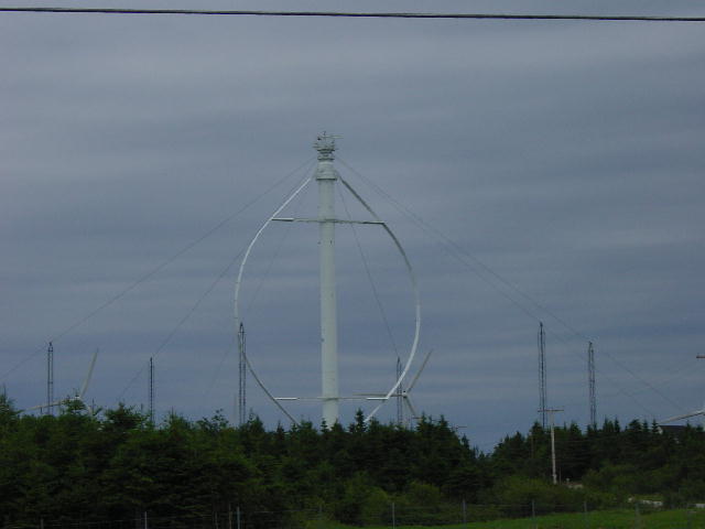
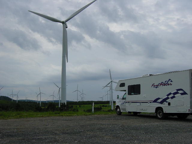
We stopped in Cap-Chat to visit Canada’s largest wind farm, Le Nordais. It was surreal to see the 133 wind turbines scattered around the hillsides along the peninsula coast. Most of the wind turbines have a three-blade propeller 150 feet in diameter mounted atop a 170-foot tower. There is also one vertical axis windmill that stands 350-feet tall, the tallest of its kind in the world. Apparently there is been a real boom in the growth of these alternative fuel wind farms around the world.
We continued our drive up the seaway toward Quebec City trying to get as far as we could today. We’ve been feeling pressed by our schedule that requires us to be in Wisconsin on Friday, and the distance to that end seems to be much greater than anticipated. Friday is also the deadline for the two term papers that Christine needs to submit in order to complete her course requirements for the two classes she took this term. She has been very busy reading, writing and typing along all the bumpy roads of eastern Canada over the past week. This has made for some long tiring driving stretches for me. We found ourselves returning to the heat wave as the temperature rose thirty degrees in just two hours on our drive up the seaway. The heat wave was joined by a nasty headwind that we bucked for the last hour of driving today.
We ended the day in a campground looking over the seaway about an hour east of Quebec City. We were exhausted, but had covered the distance we needed to and enjoyed very scenic roads while doing it. Three more long days of driving await us.
1) A picture from the dock in
Wednesday, June 27, 2001 Grafton, Ontario
Mark off another long day’s drive. We drove by Quebec City and Montreal on into Ontario as we approached Toronto today. We are very tired. We stopped about an hour east of Toronto along the north shore of Lake Ontario. Today was purely about driving.
Thursday, June 28, 2001 Lansing, MI
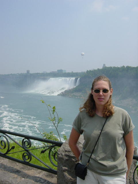
We drove through some heavy traffic in Toronto before circling around to the southern shore of Lake Ontario to visit Niagara Falls. The crowds were pretty heavy today at the falls. RV parking is strictly relegated to a lot about a mile or so from the falls. A shuttle service brought us back to the falls. We stayed on the more popular Canadian side of the falls, but that ended up being the bad side today because of the wind. It was impossible to stay dry as the wind driven mist rained down on all the spectators. The mist also washed out the view of the upper falls. Even under these conditions, the grandeur and immensity of the falls make a strong impression.
We ate lunch at the restaurant at the Table Rock visitor center before returning to the RV. We were then back underway toward the border crossing at Port Huron, MI. The crossing was uneventful and we pressed on to a campground in Lansing for the night. We celebrated the completion of Christine’s term papers. She e-mailed them in and immediately switched back into vacation mode. She cooked up a great dinner of roasted chicken with asparagus and egg noodles as I tackled the laundry. We broke out the liquor and enjoyed some well-deserved cocktails. Tomorrow’s drive puts us back in familiar territory with dinner plans at the home of my in-laws.
We are planning to spend most of July in and around Wisconsin with a base camp established at my in-laws. This will give us a chance to make several repairs needed on the RV before our long journey to Alaska in August.
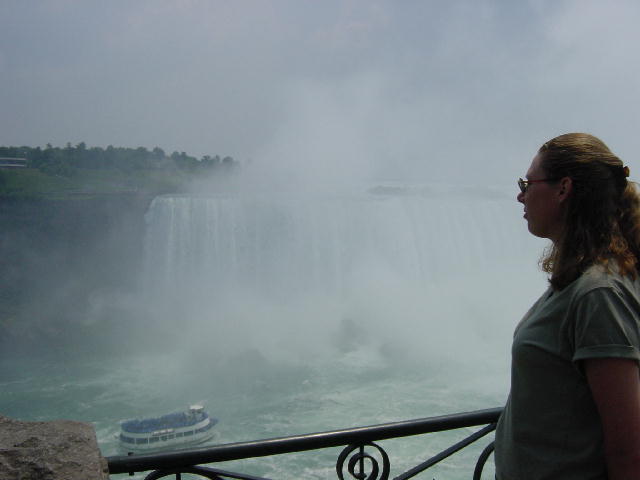
The falls from different views. In view #2, you can see the extent of the mist on this day.
Friday, June 29, 2001 Francis Creek, WI
We had to really push ourselves this morning to get started, but we got underway without too much delay. Christine volunteered to do most of the driving today with no argument from me. We made our way around the southern side of Lake Michigan through Chicago before the big weekend traffic picked up leaving Chicago. We arrived at my in-laws around 3:00 and immediately put the long drives of the past week behind us.
My mother in-law, Carol prepared a dinner of some of my favorite comfort food, meatloaf and mashed potatoes. It was good to finally be here. We made one trip out to visit Christine’s grandmother this evening. She had offered to let us use her car for a trip down to Madison and Milwaukee over the next few days.
Saturday, June 30, 2001 Madison, WI
We enjoyed sleeping in late today and starting our day slowly. Christine and I loaded up her grandmother’s car and left for Madison at 2:00 today for a planned visit with old friends of hers there. We met up with Theresa and Doug, our hosts for the evening. We were fortunate to have their guest room for the night. After a couple beers while visiting with Theresa and Doug, we all loaded into their car and drove into the city for dinner at Paisons Restaurant. We met up with Josh and Matt there. Josh was visiting from New York for a week. We had only just seen him a few weeks ago when we stayed with him in New York.
Matt is another one of Christine’s friends from her days of bartending in Madison while she was in college. This was the first time I’d met Matt. We all enjoyed a fine Italian dinner and then walked over to a nearby bar that has been a non-stop gathering point for many of Christine’s acquaintances for over ten years now. Formerly called Schooners, the bar’s new ownership had renamed it The Lava Lounge and given it a tiki hut motif.
The next six hours was a blur of friends coming and going over drinks. Before I knew it the bar was announcing last call for alcohol. We gathered up our group and walked over to a traditional bar-time hangout, La Bambas, for burritos “As Big as Your Head.” The place was packed with all the other bar patrons from nearby, now that the bars had closed.
We returned to our bed at Theresa and Doug’s house at 3:00 AM for some much needed sleep.
Continue onto July 1, 2001...